and more!Eric Daniel, Retired IT Consultant
Paul S. Forbes, Financial Advice Specialist
Damn, I wish they'd asked me.

and more!Eric Daniel, Retired IT Consultant
Paul S. Forbes, Financial Advice Specialist


Sea ice that packs the ocean around Antarctica hit record low levels this winter, the U.S. National Snow and Ice Data Center (NSIDC) said on Monday, adding to scientists’ fears that the impact of climate change at the southern pole is ramping up.
Researchers warn the shift can have dire consequences for animals like penguins who breed and rear their young on the sea ice, while also hastening global warming by reducing how much sunlight is reflected by white ice back into space.
Antarctic sea ice extent peaked this year on Sept. 10, when it covered 16.96 million square kilometers (6.55 million square miles), the lowest winter maximum since satellite records began in 1979, the NSIDC said. That’s about 1 million square kilometers less ice than the previous winter record set in 1986.
A fast-forming and strengthening El Niño climate pattern could peak this winter as one of the most intense ever observed, according to an experimental forecast released Tuesday. The new prediction system suggested it could reach top-tier “super” El Niño strength, a level that in the past has unleashed deadly fires, drought, heat waves, floods and mudslides around the world.
This time, El Niño is developing alongside an unprecedented surge in global temperatures that scientists say have increased the likelihood of brutal heat waves and deadly floods of the kind seen in recent weeks.
The formation of a supercontinent on Earth could wipe out humans and any other mammals that are still around in 250m years, according to a study.
The mass extinction would be caused primarily by heat stress as a result of greater volcanic activity that would put twice as much carbon dioxide into the atmosphere as current levels, an older sun that would emit more radiation and the extent of inland deserts in the tropics.
The supercontinent Pangea Ultima is expected to take shape when all the current continents merge together in the distant future. The paper, which was published on Monday in Nature Geoscience, is the first attempt to model how extreme the climate might become from that geological rearrangement.
Using a UK Met Office climate model and the University of Bristol supercomputer, the simulation also provided tectonic clues to past extinction events and data that could be of use to astronomers looking for other habitable planets.
only 250 million yearsAndyinPA wrote: ↑Wed Sep 27, 2023 11:58 am A bit further into the future:
https://www.theguardian.com/science/202 ... y-predicts
To bring that time frame into perspective... Mammals first appear in the fossil record during the late Triassic, 225 million years ago. No need to panic.RTH10260 wrote: ↑Wed Sep 27, 2023 6:20 pmonly 250 million yearsAndyinPA wrote: ↑Wed Sep 27, 2023 11:58 am A bit further into the future:
https://www.theguardian.com/science/202 ... y-predicts

Too late.much ado wrote: ↑Wed Sep 27, 2023 6:28 pmTo bring that time frame into perspective... Mammals first appear in the fossil record during the late Triassic, 225 million years ago. No need to panic.RTH10260 wrote: ↑Wed Sep 27, 2023 6:20 pmonly 250 million yearsAndyinPA wrote: ↑Wed Sep 27, 2023 11:58 am A bit further into the future:
https://www.theguardian.com/science/202 ... y-predicts
Try breathing deeply for the next 2 or 3 million years. You'll be fine.
Where will evolution take us in this time? By "us" I mean not necessarily Homo Sapiens...Australopithecus Afarensis was the earliest form of hominids, which archaeologists dug up fossils in the Afar Triangle of Africa, hence the name “Afarensis”. Australopithecus afarensis is an extinct hominin species that lived approximately 3.9 to 2.9 million years ago during the Pliocene and early Pleistocene epochs.
https://earthhow.com/human-evolution-timeline/
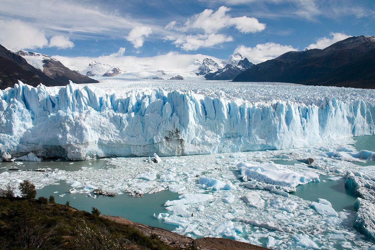
Swiss glaciers have lost 10% of their volume in just two years, a report has found.
Scientists have said climate breakdown caused by the burning of fossil fuels is the cause of unusually hot summers and winters with very low snow volume, which have caused the accelerating melts. The volume lost during the hot summers of 2022 and 2023 is the same as that lost between 1960 and 1990.
The analysis by the Swiss Academy of Sciences found 4% of Switzerland’s total glacier volume vanished this year, the second-biggest annual decline on record. The largest decline was in 2022, when there was a 6% drop, the biggest thaw since measurements began.
Experts have stopped measuring the ice on some glaciers as there is essentially none left. Glacier Monitoring in Switzerland (Glamos), which monitors 176 glaciers, recently halted measurements at the St Annafirn glacier in the central Swiss canton of Uri since it had mostly melted.
Warmer ocean temperatures have likely caused the sudden and shocking disappearance of billions of snow crabs in Alaska, which had previously baffled scientists and environmentalists, a new study has shown.
The eastern Bering Sea snow crabs, once thought to be overfished, actually starved to death en masse because the change in water temperature “increased their caloric needs considerably”, scientists at the National Oceanic and Atmospheric Administration said in the study.
The years 2018 and 2019 saw record-breaking ocean temperatures, which at first led to a boom in the snow crab population before it quickly plummeted. Then 2022 saw a sharp decline of 10 million crabs.
A marine heatwave, which happens when ocean temperatures are persistently and anomalously warm, causes stress to corals and other marine ecosystems, leaving sea life vulnerable and causing chaos across food chains. The phenomenon is a product of the climate crisis since “the ocean absorbs 90% of the excess heat associated with global warming”, the Noaa said.
Arctic temperatures have warmed four times faster than those of the rest of the planet, scientists said.
As the ocean warms, Greenland’s last remaining ice shelves are rapidly weakening, destabilizing the nearby glaciers and threatening potentially “dramatic” consequences for sea level rise, according to the study published Tuesday in Nature Communications.
Ice shelves are tongues of floating ice that jut out over the ocean and act as dams that hold back glaciers on land and slow ice loss. When they melt and weaken, more of the land-based ice is able to slide into the ocean, adding to sea level rise.
Scientists analyzed eight ice shelves buttressing glaciers in northern Greenland, which together hold enough ice to raise sea levels by 2.1 meters — nearly 7 feet — should they break down and melt completely.
“These glaciers are among the most important of the ice sheet,” Romain Millan, a glaciologist at the Grenoble Alpes University in France and an author of the study, told CNN. “They are the largest glaciers of Greenland.”
While glaciers in other parts of Greenland started to lose mass in the 1980s and 1990s, he said, so far, those in northern Greenland “have remained relatively stable.”
But this appears to no longer be the case, according to the study.
Millan and his co-authors used thousands of satellite images, along with climate models and measurements from the field, to better understand the drivers for — and timing of — historical and current changes to the ice shelves.
They found a “substantial and widespread” increase in ice shelf losses. Since 1978, the ice shelves supporting northern Greenland’s glaciers have lost more than 35% of their total volume, according to the study. It found that since the early 2000s, three have collapsed completely, and the remaining five are melting and destabilizing nearby glaciers.
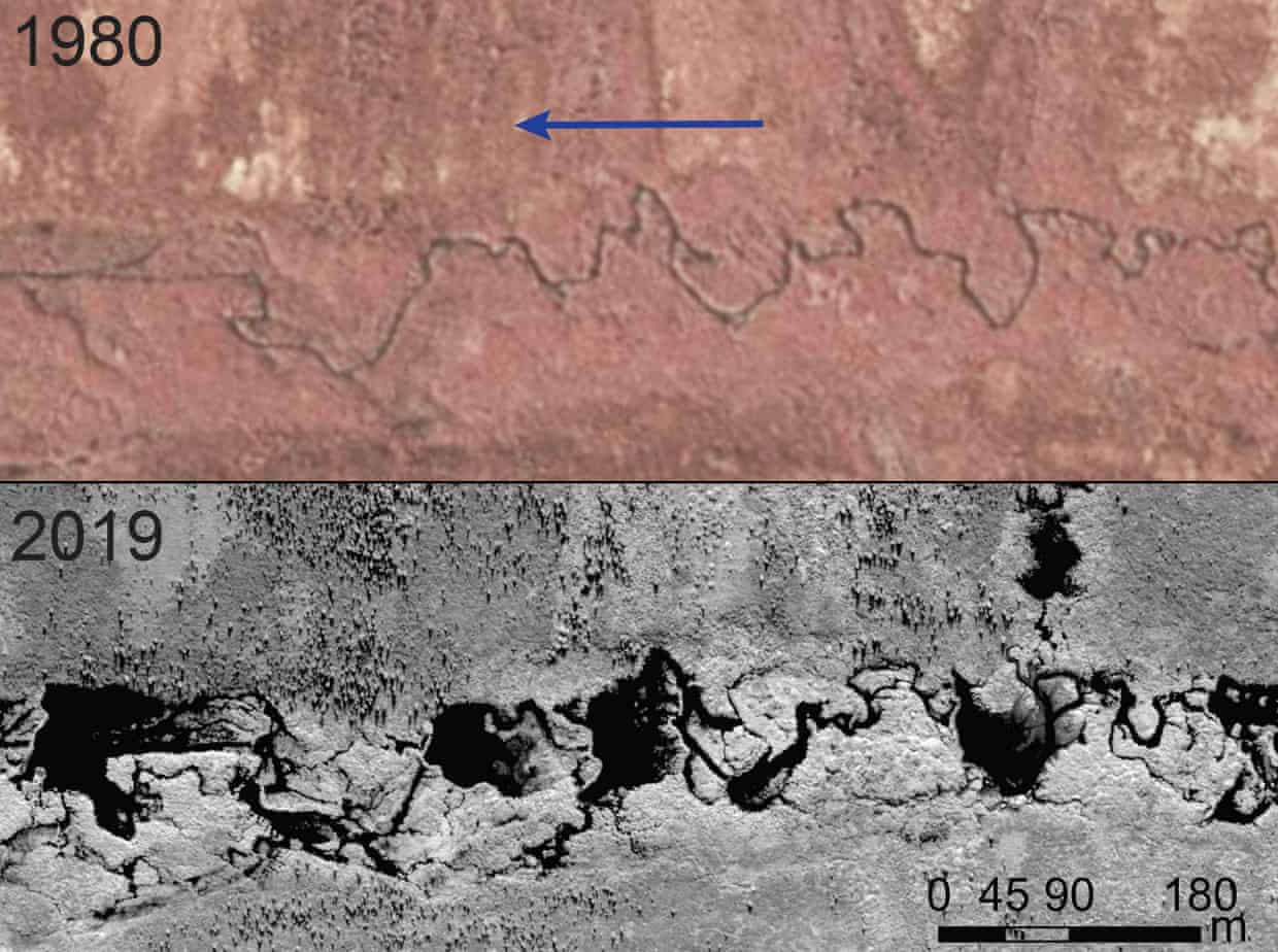
The stream through western Alaska never looked like this before. In aerial photography from the 1980s, it wove cleanly through the tundra, thin as thread. Today, in satellite images, it appears as a string of black patches: one large pond after another, dozens of metres apart.
It’s a transformation that is happening across the Arctic, the result of landscape engineering on an impressive scale. But this is no human endeavour to reshape the world. It is the work of the North American beaver, and there is no sign of it stopping.
Were the waddling rodents making minor inroads, researchers may never have noticed. But the animals are pouring in, pushing north into new territories. The total number of animals is far from clear, but the ponds they create are hard to miss: in the Arctic tundra of Alaska alone, the number of beaver ponds on streams have doubled to at least 12,000 in the past 20 years. More lodges are dotted along lakes and river banks.
In the other hand, my nice in Whistler BC says they're having the worst season ever.AndyinPA wrote: ↑Tue Jan 02, 2024 7:54 pm Generally speaking, beaver ponds are a good thing (except to humans). That's fascinating, and says a lot about the degree of climate change.
At the moment, people I know in Alaska are having a lot of snow so far this winter, They are in the Anchorage/Palmer area.
World’s largest iceberg, A23a, is adrift and seeing major erosion and melting
ByEric Ralls Earth.com staff writer
01-18-2024
The world’s largest iceberg, A23a, is undergoing significant erosion and transformation as it moves away from Antarctica. Captured in new photos and videos, the iceberg, measuring 1,540 square miles, is being reshaped by ocean waters, forming caves and arches.
The erosive process, similar to coastal land erosion, is accelerated by waves crashing against the iceberg, gradually enlarging gaps until the top layers collapse.
Mind-boggling size
EYOS Expeditions, who recently visited iceberg A23a, deployed a drone for aerial photography. Expedition leader Ian Strachan described the scene, thusly.
“We saw waves, a good three meters or four meters high, smashing into the berg… These were creating cascades of ice – a constant state of erosion.”
“It’s mind-bogglingly big and stretches as far as you can see in both directions… It’s certainly too big to photograph,” added videographer Richard Sidey.
The erosion process involves powerful waves hitting the iceberg’s base, creating small gaps that eventually widen into caves and arches, leading to the collapse of the ‘roof’ or the top ice layer. This leaves behind smaller stacks that eventually melt away.
Potential impact of iceberg A23a
A23a, grounded to the ocean floor for 30 years, is now drifting northwards due to wind and ocean currents.
The British Antarctic Survey (BAS) revealed that the iceberg is moving at about 30 miles per day and may enter “iceberg alley” towards South Georgia.
According to a BAS spokesperson, “it depends on its trajectory, but there is potential for impact to wildlife if it approaches any of the sub-Antarctic islands.”
Originally part of the Filchner Ice Shelf, A23a became stationary after grounding, a phenomenon that occurs when an iceberg’s keel is deeper than the water’s depth.
Scientists noted its movement in November, with the iceberg now on a northward journey.
https://www.earth.com/news/worlds-large ... r-erosion/
A crucial system of ocean currents may already be on course to collapse, according to a new report, with alarming implications for sea level rise and global weather — leading temperatures to plunge dramatically in some regions and rise in others.
Using exceptionally complex and expensive computing systems, scientists found a new way to detect an early warning signal for the collapse of these currents, according to the study published Friday in the journal Science Advances. And as the planet warms, there are already indications it is heading in this direction.
The Atlantic Meridional Overturning Circulation (the AMOC) — of which the Gulf Stream is part — works like a giant global conveyor belt, taking warm water from the tropics toward the far North Atlantic, where the water cools, becomes saltier and sinks deep into the ocean, before spreading southward.
The currents carry heat and nutrients to different areas of the globe and play a vital role in keeping the climate of large parts of the Northern Hemisphere relatively mild.
For decades, scientists have been sounding the alarm on the circulation’s stability as climate change warms the ocean and melts ice, disrupting the balance of heat and salt that determines the currents’ strength.
While many scientists believe the AMOC will slow under climate change, and could even grind to a halt, there remains huge uncertainty over when and how fast this could happen. The AMOC has only been monitored continuously since 2004.
Scientists do know — from building a picture of the past using things like ice cores and ocean sediments — the AMOC shut down more than 12,000 years ago following rapid glacier melt.
The average ice cover over the five Great Lakes was just 6% last month, placing it among the least icy Januarys since records began 50 years ago, according to the National Oceanic and Atmospheric Administration (Noaa).
The Great Lakes – Superior, Huron, Michigan, Erie and Ontario – are located at or near the US-Canada border, and are connected by a network of smaller lakes and rivers that span a combined surface area of 95,000 sq miles, making it the largest freshwater system in the world.
While some year-to-year variation in ice cover is normal, scientists say global heating is driving ice loss and warmer water temperatures, and is likely to worsen if no action is taken soon.
“In direct response to warming air temperatures, we are observing rapid ice loss and warming summer water temperatures,” said Professor Sapna Sharma, an expert in environmental stressors on lakes at York University in Toronto. “If the planet continues to warm, 215,000 lakes may no longer freeze every winter and almost 5,700 lakes may permanently lose ice cover by the end of the century.”
Scientists have looked back in time to reconstruct the past life of Antarctica’s “Doomsday Glacier” — nicknamed because its collapse could cause catastrophic sea level rise. They have discovered it started retreating rapidly in the 1940s, according to a new study that provides an alarming insight into future melting.
The Thwaites Glacier in West Antarctica is the world’s widest and roughly the size of Florida. Scientists knew it had been losing ice at an accelerating rate since the 1970s, but because satellite data only goes back a few decades, they didn’t know exactly when significant melting began.
Now there is an answer to this question, according to a study published Monday in the journal Proceedings of the National Academy of Sciences.
By analyzing marine sediment cores extracted from beneath the ocean floor, researchers found the glacier began to significantly retreat in the 1940s, likely kicked off by a very strong El Niño event — a natural climate fluctuation which tends to have a warming impact.
Since then, the glacier has been unable to recover, which may reflect the increasing impact of human-caused global warming, according to the report.
What happens to Thwaites will have global reverberations. The glacier already contributes 4% of sea level rise as it sheds billions of tons of ice a year into the ocean. Its complete collapse could raise sea levels by more than 2 feet.
But it also plays a vital role in the stability of the West Antarctic Ice Sheet, acting like a cork holding back the vast stretch of ice behind it. Thwaites’ collapse would undermine the stability of the ice sheet, which holds enough water to raise sea levels by at least 10 feet, causing catastrophic global flooding.